


DroneSurveys.co.uk make surveys easy
How much does a drone survey cost?

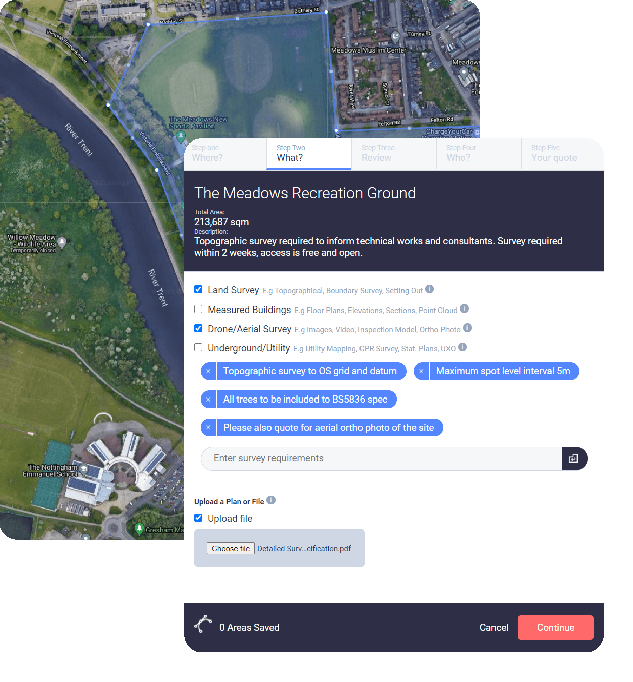
Map your site with our survey mapping tool
Click around the area to be surveyed by drone and select from Drone Survey and associated services.

Get your Drone Survey quote
We’ll contact you to discuss any details and we provide quotes as a fixed price.

Happy? Arrange access & wait for your drawings
We’ll take it from here and provide clear and accurate drawings, images and video to a pre-agreed timescale.

Chartered, regulated & insured
Why use DroneSurveys.co.uk?
Technical Expertise
We have measured all manner of land and buildings using techniques ranging from traditional hand measurements to the latest in 3d laser scanning, drones and point clouds.
Accurate and Precise
We can incorporate the use of high-end total stations, 3D laser scanners and GPS units to achieve the best results from your drone survey.
Modern service
We harness technology to bring you service designed for the modern working professional.
Combine surveys
Manage costs by combining your drone survey with other surveys often required in unison, such as topographic surveys.
Discrete & Confidential
We will not discuss your project with any third parties and will respect sensitive issues which may need to be considered.
CAA operators
RICS best practice is at the heart of our workflows and our drone pilots are certified CAA operators.
Chartered Land Surveyors offering
Aerial Drone Surveys of Land & Buildings
We provide a wide range of survey solutions including drone surveys, measured building surveys, topographic surveys, Land Registry plans and 3d laser scanning.
DroneSurveys.co.uk
Safe, fast and cost effective aerial surveys.
Browse our services and view sample surveys and examples. "Map It" to start your survey or contact us if you have a query.
Buildings
We can use drones to inspect, map and measure hard to access areas of your buildings. From simple roof plans to digital twins.
Construction
Drone surveys can provide a snapshot of your construction site, for site analysis, planning and design, asset inventory, project reporting and collaboration..
Land
We regularly incorporate drones into our topographic surveys. The extra 2D & 3D colour formats are valuable datasets for clients.
Events and Marketing
Aerial photography and video using a drone allows us to capture your event or marketing material from a unique perspective.
Boundaries
Drones can be a useful tool to inspect and measure changes to boundaries, where access is difficult. CPR35 Expert Witness work for commercial clients.
GIS
A large scale orthophoto can provide an up to date and accurate base layer map for your geographical information system, enhancing spatial relationships between assets.
DroneSurveys.co.uk
Helping you understand your site
Our expertise lies in digitising both the natural and constructed environment. We can deliver outputs in a wide choice of electronic formats, catering to diverse architectural, planning, and engineering fields and expertise.


